The chapel of La Salette - Beaujolais Vert - Joux
schwer
Navigieren
Navigieren
Hol diese Tour auf dein Handy
The chapel of La Salette - Beaujolais Vert - Joux
schwer
Wanderung
19,90
km
QR-Code scannen und Navigation in der bergfex App beginnen

Wandern & Tracking


The chapel of La Salette - Beaujolais Vert - Joux
schwer
Distanz
19,90
km
Dauer
07:00
h
Aufstieg
692
hm
Seehöhe
472 -
890
m
Track-Download
The chapel of La Salette - Beaujolais Vert - Joux
schwer
Wanderung
19,90
km
You'll love:
• A complete, athletic trail, lightly paved with some elevation gain. Before setting off, prepare for a 1.5-2 hour gradual climb to the GR®7. At Moulin Lafay, redouble your efforts to tackle...
Beschreibung
You'll love:
• A complete, athletic trail, lightly paved with some elevation gain. Before setting off, prepare for a 1.5-2 hour gradual climb to the GR®7. At Moulin Lafay, redouble your efforts to tackle the last, steepest kilometers.
• The beauty of the landscapes and the wild nature. Around Joux, the Tarare mountains are steep, the mountain uninhabited. Here, the forest, the sound of rivers, and birdsong reign.
• The Saint-Cyr-de-Valorges pond, nestled on the edge of the woods.
• Two great panoramas: around Croix Armide, where the landscape runs from east to west, with the Alps on one side and the Forez on the other. Further on, from the chapel, admire the plunging view of Joux.
You'll enjoy it best:
• In any season. The mountain views are most admirable in winter, when the mountains emerge from the sea of clouds under pure blue skies. Bring binoculars!
• Outside of the warmer months, the GR®7 is windy. Wear suitable clothing and footwear for trekking on stony and muddy paths in places.
• Sit down at a picnic table by the Saint-Cyr pond or in the picnic area for a midday snack. Save dessert for a relaxing break on the way back to the chapel.
• While strolling through Joux, discovering its unusual heritage.
A bit of culture:
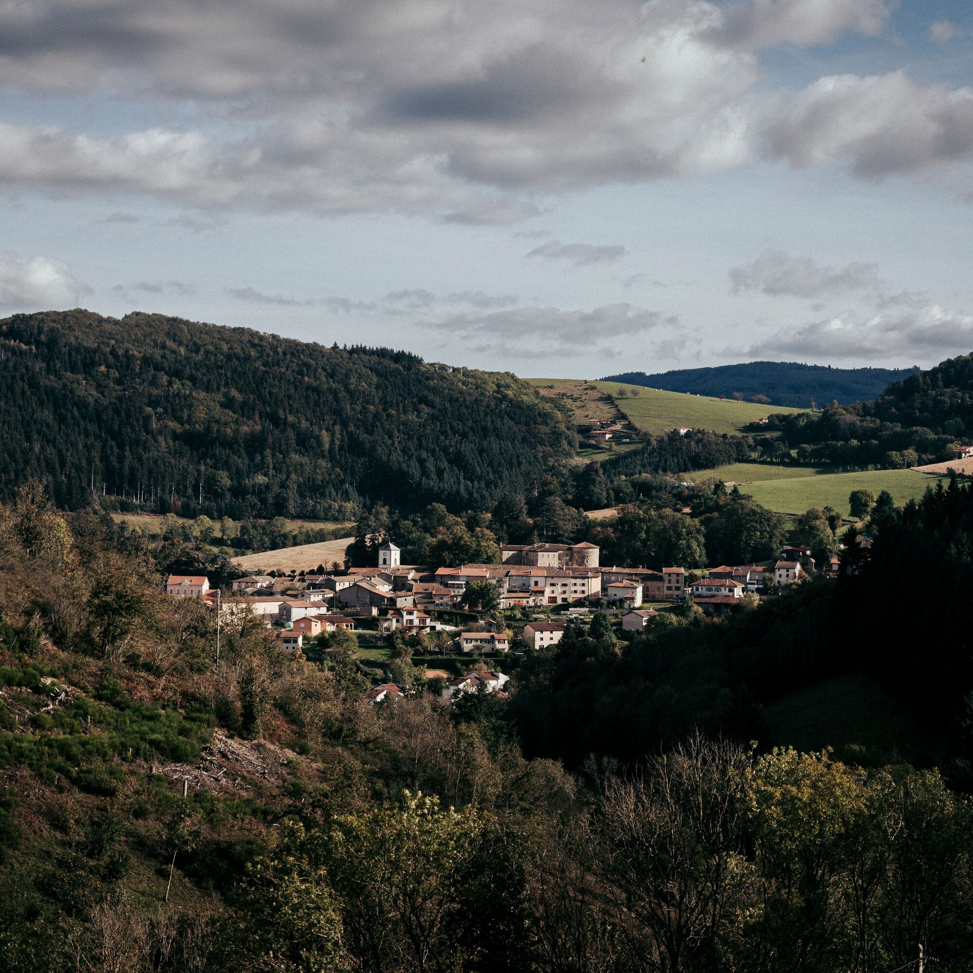
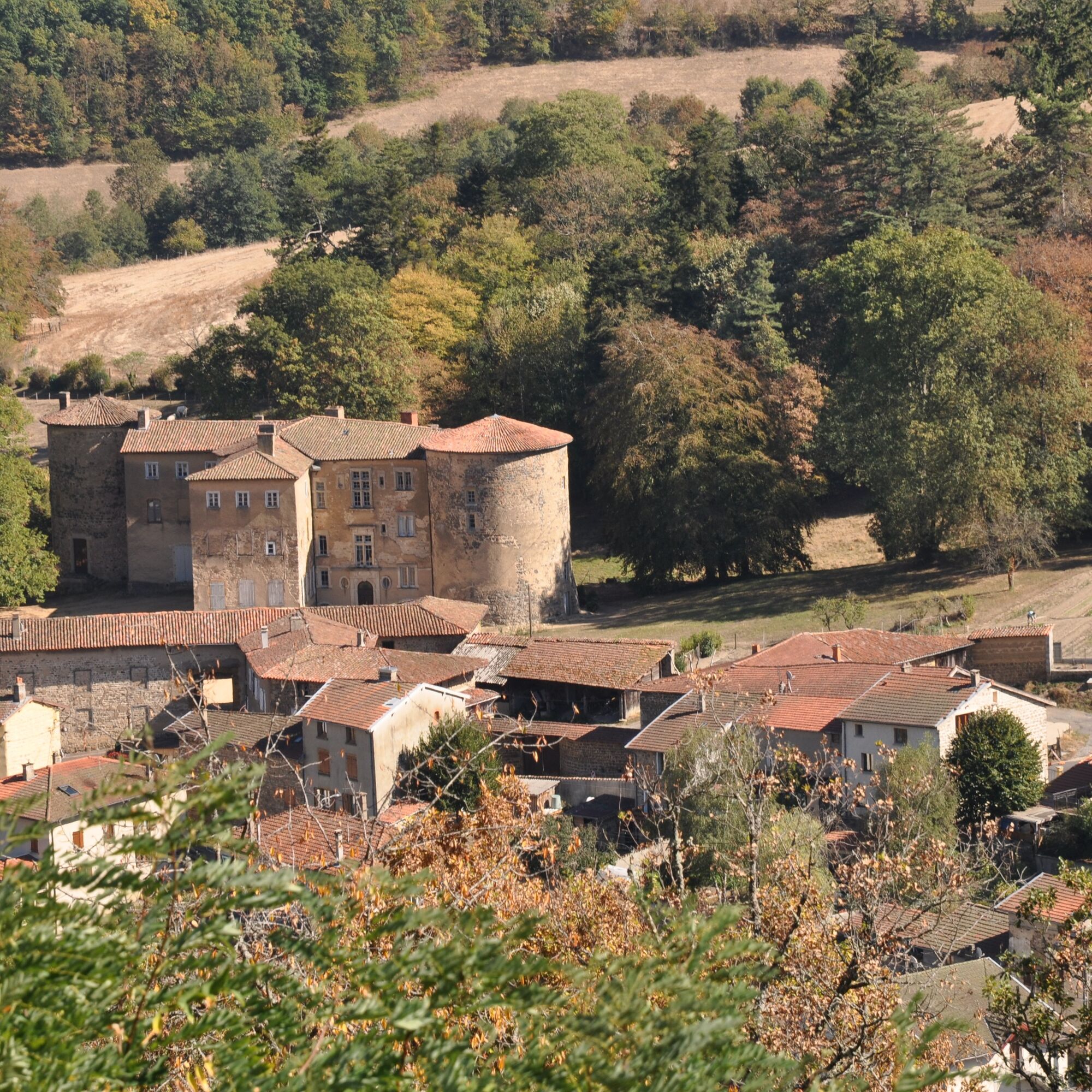
Joux seen from the Notre-Dame-de-la-Salette chapel
The building has watched over the village for nearly 150 years. Research conducted by the conservation association created for its preservation reveals that it was built to protect soldiers engaged in the Franco-German conflict of 1870.
From the chapel, the view sweeps over the village and is drawn towards the dam and the castle. One can also see the unique layout of Joux, which was surrounded by a rampart walk in the Middle Ages.
The castle is best admired from the exterior as it is privately owned. The first mention of its existence dates back to the 11th century. Since its origins, it has belonged to two families and has always been inhabited. Located off-center from the village, the dam is a reminder of the once-prosperous textile industry in theTurdine Valley. It supplied the factories with water. With very little limestone, this water is now used, in particular, for brewing beers.
• A complete, athletic trail, lightly paved with some elevation gain. Before setting off, prepare for a 1.5-2 hour gradual climb to the GR®7. At Moulin Lafay, redouble your efforts to tackle the last, steepest kilometers.
• The beauty of the landscapes and the wild nature. Around Joux, the Tarare mountains are steep, the mountain uninhabited. Here, the forest, the sound of rivers, and birdsong reign.
• The Saint-Cyr-de-Valorges pond, nestled on the edge of the woods.
• Two great panoramas: around Croix Armide, where the landscape runs from east to west, with the Alps on one side and the Forez on the other. Further on, from the chapel, admire the plunging view of Joux.
You'll enjoy it best:
• In any season. The mountain views are most admirable in winter, when the mountains emerge from the sea of clouds under pure blue skies. Bring binoculars!
• Outside of the warmer months, the GR®7 is windy. Wear suitable clothing and footwear for trekking on stony and muddy paths in places.
• Sit down at a picnic table by the Saint-Cyr pond or in the picnic area for a midday snack. Save dessert for a relaxing break on the way back to the chapel.
• While strolling through Joux, discovering its unusual heritage.
A bit of culture:
Joux seen from the Notre-Dame-de-la-Salette chapel
The building has watched over the village for nearly 150 years. Research conducted by the conservation association created for its preservation reveals that it was built to protect soldiers engaged in the Franco-German conflict of 1870.
From the chapel, the view sweeps over the village and is drawn towards the dam and the castle. One can also see the unique layout of Joux, which was surrounded by a rampart walk in the Middle Ages.
The castle is best admired from the exterior as it is privately owned. The first mention of its existence dates back to the 11th century. Since its origins, it has belonged to two families and has always been inhabited. Located off-center from the village, the dam is a reminder of the once-prosperous textile industry in theTurdine Valley. It supplied the factories with water. With very little limestone, this water is now used, in particular, for brewing beers.
Wegverlauf
Le Tilia
(519 m)
Restaurant
0,4 km
Église de l'Assomption
(520 m)
Andachtsstätte
0,4 km
Joux
(510 m)
Dorf
0,6 km
La Salette
(606 m)
Flur/Gelände
18,2 km
Chapelle Notre-Dame de la Salette
(605 m)
Andachtsstätte
18,3 km
Joux
(510 m)
Dorf
19,2 km
Église de l'Assomption
(520 m)
Andachtsstätte
19,5 km
Wegverlauf
The chapel of La Salette - Beaujolais Vert - Joux
schwer
Wanderung
19,90
km
Le Tilia
(519 m)
Restaurant
0,4 km
Église de l'Assomption
(520 m)
Andachtsstätte
0,4 km
Joux
(510 m)
Dorf
0,6 km
La Voisinée Marsande
(563 m)
Siedlung
1,3 km
La Salette
(606 m)
Flur/Gelände
18,2 km
Chapelle Notre-Dame de la Salette
(605 m)
Andachtsstätte
18,3 km
Joux
(510 m)
Dorf
19,2 km
Église de l'Assomption
(520 m)
Andachtsstätte
19,5 km
Le Tilia
(519 m)
Restaurant
19,5 km
Autor
Bereitgestellt von Rhône Tourisme
Die Tour The chapel of La Salette - Beaujolais Vert - Joux wird von outdooractive.com bereitgestellt.

Noch keine Bewertungen
Beliebte Touren in der Nähe
Circuit de découverte du patrimoine
leichtWanderung 2,19 kmDes dégringoules* au vert - Beaujolais - Amplepuis
leichtWanderung 5,13 kmDer kleine Rundweg Crêt d’Arjoux - Monts du Lyonnais - Saint-Julien-sur-Bibost
leichtWanderung 4,93 kmThe forest of Brou - Beaujolais - Dième
leichtNordic Walking 10,5 kmMa première nuit étoilée - Beaujolais - Tarare
schwerWanderung 36,5 kmCircuit VTT n°113 rouge : En lisière des communes
schwerMountainbike 16,8 kmAround the Lac des Sapins - Beaujolais Vert - Cublize
leichtWanderung 4,76 kmMonts du Lyonnais - Die Schleife des Landes von Chamousset - 2.3
leichtRennrad 34,9 kmTrail around Lac des Sapins - Beaujolais Vert - Cublize
schwerTrailrunning 15,0 kmCircuit VTT n°107 rouge : Les 3 rivières
schwerMountainbike 19,1 km
Wandern & Tracking

Über 550.000 Tourenvorschläge, detailliertes Kartenmaterial und ein intuitiver Routenplaner machen die App zum Must-have für alle Naturbegeisterten.

Verpasse keine Angebote und Inspirationen für deinen nächsten Urlaub
Zum Newsletter anmelden
Fehler
Ein Fehler ist aufgetreten. Bitte versuche es erneut.Vielen Dank für deine Anmeldung
Deine E-Mail-Adresse wurde in den Verteiler eingetragen.
Touren in ganz Europa
Österreich Schweiz Deutschland Italien Slowenien Frankreich Niederlande Belgien Polen Liechtenstein Tschechien Slowakei Spanien Kroatien Bosnien und Herzegowina Luxemburg Andorra Portugal Island Vereinigtes Königreich Irland Griechenland Albanien Nordmazedonien Malta Norwegen Montenegro Moldau Kosovo Ungarn San Marino Rumänien Estland Lettland Belarus Zypern Litauen Serbien Bulgarien Monaco Dänemark Schweden Finnland